
History of San Felipe:
Exploration of Northern Baja California
![]()
THE HISTORY OF SAN FELIPE, BAJA CALIFORNIA, MEXICO
CHAPTER VI: EXPLORATION OF NORTHERN BAJA CALIFORNIA AND THE UPPER GULF
I. FRANCISCO DE ULLOA
Commanding three ships, Francisco de Ulloa in 1539, began exploration of the Gulf. In honor of the conquistador of Mexico, Ulloa first applied the name Mar de Cortes (Sea of Cortes) to the Gulf of California. Ulloa was the first to explore both interior coasts of the Gulf. He passed San Felipe Bay, but his diary makes no mention of the bay or its environs. Bancroft writes, "The details of Ulloa's voyage have for the most part no geographical importance, as but very few of the points mentioned can be identified..." [Hubert Howe Bancroft, History of North Mexican States and Texas (Berkeley: University of California Press), p. 79.]
Ulloa's main aim was to sail as far north as possible. He accomplished this upon reaching the Colorado River and refuting the claims that Baja California was an island. In subsequent years other ships sailed to the Colorado River but none made note of San Felipe Bay.
|
|
II. MISSIONARIES ON THE PENINSULA
The Spanish rulers of Mexico realized that the peninsula offered no riches. Therefore, forceful takeover of the land and natives was not rapid. The Spaniards resorted to an alternate method of land appropriation--the church. For a period of two hundred years, from the middle 1500's to the early 1700's, northern Baja California remained unexplored and unsettled while intrepid Jesuit missionaries gained footholds in the southern peninsula region. For over one hundred years northern exploration was nearly impossible for it took all the missionaries' energy just to secure initial southern settlements.
Thorough investigation of the northern peninsula did not begin until the early 1700's. For the purpose of establishing future mission sites, three black robes explored what was to be called San Phelipe de Jesus, two of whom made note of their observations.
Voyage of Ugarte. Rev. Pedro de Ugarte sailed from Loreto on May 15, 1721, carrying on board thirteen Californians, six Europeans, and an English pilot, William Strafford. After a hazardous journey to the mouth of the Colorado, Ugarte's voyage was a true geographical exploration of the gulf. The Padre is given credit for naming all islands, harbors, bays, and ports of the northern gulf, including San Felipe Bay. [J. Ross Browne, Resources of the Pacific Slope (New York, 1887), p. 11.] Though Ugarte's diary makes no mention of San Phelipe de Jesus, speculation is that the party reached the bay on the calendar day of St. Phillip, August 23rd. Thus the bay was designated in the saint's honor.
Fr. Consag's exploration of the gulf. Laboring for the Society of Jesus in Baja California, Father Fernando Consag was the first to give a thorough account of San Felipe Bay. Ordered by the Father-Provincial in 1746, Consag set out from Mission San Ignacio to explore possible mission sites northward to the Colorado River. The voyage was made at the expense of the missions, each one contributing what it could.
Consag's party related the first description of San Felipe. His diary reads:
We next came to the bay of San Phelipe de Jesus, the cape of which lies north and south from one another. That of the north terminates in some black mountains..and found it to afford a shelter against the north wind, even for large vessels... [Msgr. M. D. Krmpotic, Life and Works of Reverend Ferdenand Konscak S. J. (Boston: Stratford Company 1923), p. 74.]
This observation had an important bearing on the use of San Felipe as a port for supplying future missions of the peninsula's northern interior.
The shore is sandy, and on the north side is a creek, which at full and change of the moon has a depth of water sufficient for boats, but at other times is dry. [Ibid.]
Consag is undoubtedly referring to the small tidal lagoon found today at San Felipe.
At the foot of a flat eminence it [San Felipe] affords plenty of water, but thick, disagreeable, of an ill smell, and noxious in its quality. Its effects on those who drink it resembles the symptoms of scurvy. [Ibid.]
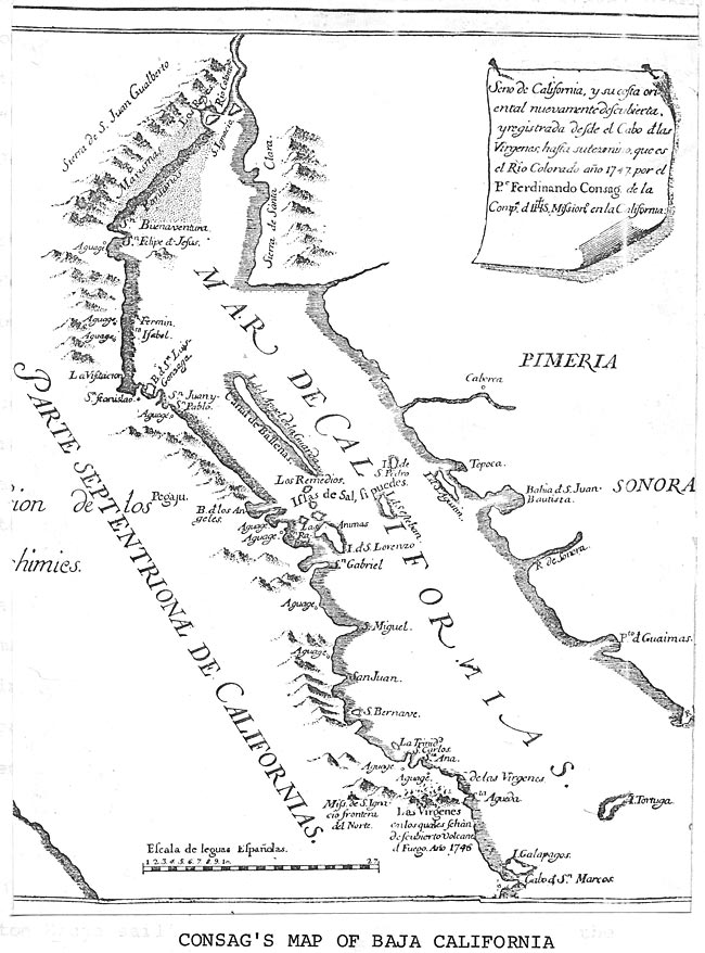
Although disagreeable, the water must have been potable, for Consag maps San Felipe as one of the few spots on the eastern gulf coast with drinking water (aguage), (fig, 9). Consag concludes his remarks with a warning to all future travelers, "all the way from San Phelipe to the River Colorado there is neither bay nor watering place." [Ibid., p. 75.] His accounts and map made available knowledge of San Felipe Bay with its utility for missionary endeavors.
|
Figure 9. Consag's Map of Baja California. |
The last explorer-Padre. Three years before Jesuit missionary work was to be replaced by the Franciscans, Father Winceslao Link made a difficult journey from San Borja with the intention of reaching the Colorado River by land. The following is his account of San Felipe:
Our neophytes who went to the beach yesterday, returned at nightfall. Most of them lacked the strength to traverse the entire sandy stretch. Some of the more energetic reached the Gulf itself and on the beach discovered a native settlement near a water well. All the pagan Indians fled except two whom they brought to us at midnight. [Ernest J. Burrus (Trans.), Wenceslaus Linck's Diary of his 1766 Expedition (Los Angeles: Dawson's Book Shop, 1966), p. 71.]
Dr. Ronald L. Ives has mapped Link's route of travel based on the padre's diary. [Ibid.] Ives notes that the water well near the present town of San Felipe was very likely the "aguage" shown on Consag's map, opposite San Phelipe de Jesus.
Consag's initial exploration of San Felipe, substantiated by Link's discussion, literally placed San Felipe on the map. The presence of water and a protective bay was known to all travelers and potential settlers.
Between 1721 and 1767 San Felipe Bay had been discovered and explored. The dominant purpose for the initial explorations of Ugarte, Consag, and Link was to find areas in the northern peninsula that might have usefulness to the missionary cause.
Consag found San Felipe Bay to offer drinking water and good ship protection, thus he included the bay in his map and applied the important aguage designation signifying the presence of potable water. The combination of potable water and boat protection made San Felipe unique among the bays of the peninsula's east coast.
III. AN ENGLISHMAN IN THE GULF
The year was 1826: in command of the twenty-five ton Bruja sailing northward toward the mouth of the Colorado River was Lt. R. W. H. Hardy. He was engaged by the General Pearl and Coral Fishery Association of London to find beds of pearl oysters. Besides pearl hunting, his employers also urged him to keep alert for news of sunken ships or for gold and silver mines. [Eugene L. Conrotto, "He Sailed into the Unknown Rio Colorado," Desert Magazine, XXII, (February, 1959.]
Hardy's travels led him to rename the northern and southern headlands of San Felipe Bay, and also the small island lying off shore. To this island Hardy designated the name Clarence Island. Today the island is known as Consag Rock. Hardy was not familiar with Consag's map, for he was ignorant of the name San Felipe which had been applied by Father Consag. Analysis of Hardy's map, latitude and longitudinal positioning, in conjunction with his description, confirms the area as San Felipe Bay (fig. 10). The diary of his travels relates:
A little before noon we passed about a league to windward of this island, and ascertained its latitude to be 31°15' north and longitude 113°45' west...To this new island I gave he name of Clarence Island, in honour of His Royal Highness Duke of Clarence, who, as Lord High Admiral of England, gave such universal satisfaction to the country by promoting to the rank of Lieutenant, a number of midshipmen who had grown grey in the service, without a hope of their ending their fretful days out of dismal cockpit. [Lieut. Robert W. H. Hardy, Travels in the Interior of Mexico in 1825, 1827, and 1828. (London: Henry Colburn and Richard Bentley, 1829), p. 318.]
|
Figure 10. Hardy's Route of Exploration in the Gulf. |
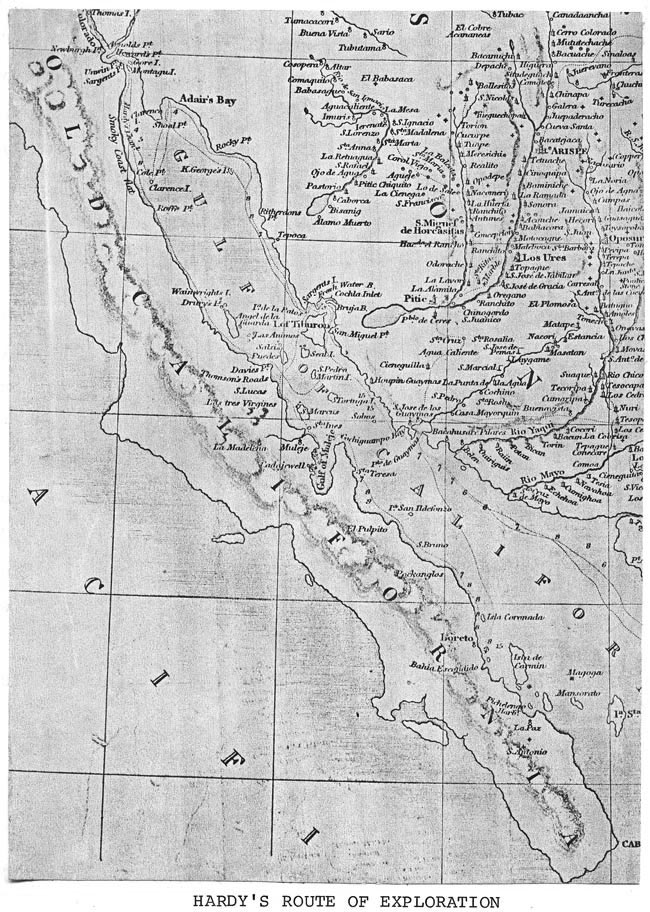
The island Hardy refers to is the modern day Consag Rock or Island, which lies approximately twenty-two miles off the shore of San Felipe Bay. Hardy's description continues:
At ten A.M. of the 20th we passed Clarence Island,leaving it at a small distance eastward. It appears to be composed of alternate strata of lime and sandstone, at an angle of about 35° or 40° from the perpendicular. It is of considerable elevation, and about a mile in circumference. [Ibid.]
Hardy gave a rather accurate description of the island. It is two hundred eighty-six feet high and three kilometers long. Its steep gradient culminating in a pinnacle, it resembles a sailing ship on the horizon.
|
|
Hardy's vessel approached the northern point of the bay known today as San Felipe Point. His diary accounts, "At noon we were close into a high bluff, which I have named Cole Point, on the Gulf coast in eight fathoms of water..." [Ibid., p. 320.]
His diary resumes with a description of land north of San Felipe Point (Cole Point):
The California shore, that is to say from Cole Point to Rio Colorado, was in a continued smoke, from fine particles of sand which the wind carried full a mile into the air. I could distinguish what I supposed to be the direction of the coast formed over it, and I christened it "Smokey Coast" in consequence. [Ibid., p. 321.]
North of Point San Felipe (Cole Point) the coast is very regular, composed of alluvial sands meeting the gulf's flood plain, often an area of high winds and blowing sand. The description further substantiates his presence at San Felipe Bay.
Hardy's journal terminates with the following remarks:
At seven A.M. saw Clarence Island bearing southeast, Cole Point, [Point San Felipe] west by north, Roffe Point [Punta Estrella], southwest. I must advertise to the reader that with the exception of King George's Island and Clarence Island, I have given to the other places now, for the first time discovered, the names of my particular friends. It is probably the only public tribute which I shall ever be able to pay to individuals who stand so high in public and private estimation, and for whose kindness I have personally so many reasons to be grateful. [Ibid., p. 383-4.]
Hardy was the last to write about the San Felipe area for fifty years. The designation of Cole Point, Roffe Point, and Clarence Island faded with time, but many of the names assigned to the upper gulf remain today; these include Montague Island, Gore Island, and Adair Bay. Rio Hardy, the distributary of the Colorado River, is named in Lieutenant Hardy's honor.
TABLE OF CONTENTS: HISTORY OF SAN FELIPE SITE EVOLUTION, BY THOMAS ANTHONY TERICH
(Related San Felipe articles and reports may be found at Mexfish.com's main San Felipe information page. See weekly fishing news, photos, and reports from the major sportfishing vacation areas of Mexico including the San Felipe area in "Mexico Fishing News.")
MEXICO FISHING INFO SAN FELIPE FISHING INFO "WEEKLY MEXICO FISHING NEWS" FISH PHOTO GALLERY