
San Felipe History: Weather and Climate of San Felipe
![]()
THE HISTORY OF SAN FELIPE, BAJA CALIFORNIA, MEXICO
CHAPTER II: WEATHER AND CLIMATE OF SAN FELIPE
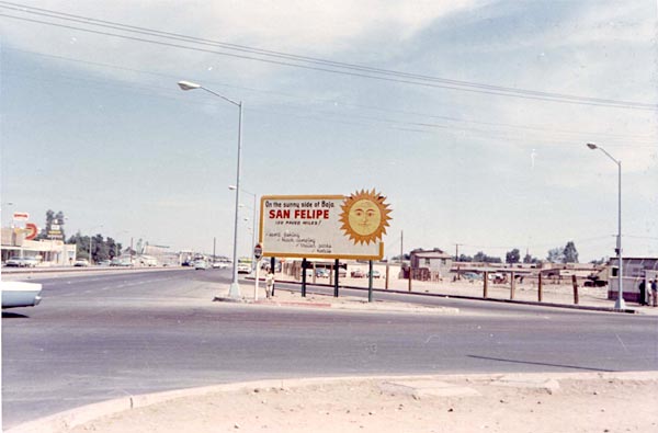
Mountains of the peninsula of Baja California stand as an effective barrier against eastward-moving, Pacific air masses. The eastern side of the peninsula has often been referred to as the "sunny side" of Baja California. San Felipe, situated on the "sunny side," boasts an average of three hundred days of clear skies each year (plate 1).
|
Plate 1. Tourist-appealing Road Sign. |
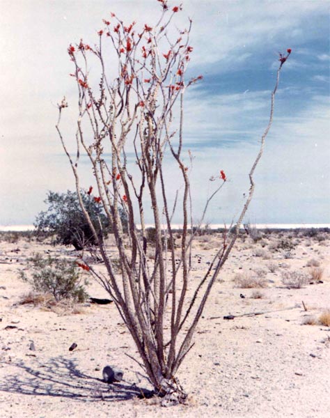
Water is at a premium on the gulf side of Lower California. Less than three inches of rainfall per year is not unusual for land bordering the western shore of the Gulf. Only the hardiest xerophytic vegetation can survive under the arid conditions of Baja California's eastern dry lands. Alluvial sands dotted with the ubiquitous creosote bush (Larrea divaricata), burro bush (Fransira dumosa), and brittle bush (Encelia farinosa), slope to the shore of the gulf. The unique ocotillo (Fouquieria splendens) give an added flare to the desert vegetation. Particularly during spring, the ocotillo's red bloom decorates the arid environment (plate 2).
|
Plate 2. Blooming Ocotillo in the Desert. |
Man's settlements have been surprisingly successful in the arid lands of Baja California. The location of an adequate water source to support settlement was the most important determinant of mission establishment in the seventeenth and eighteenth centuries. The Indians and missionaries could reside with some security only where water was nearby. Rainfall is light and permanent surface streams are missing. An examination of San Felipe's relative position will illustrate the type of weather and climate.
I. CONTROLS OF WEATHER AND CLIMATE
|
|
The climatic conditions of San Felipe are influenced by two important control elements: latitudinal position and the orographic barrier of the peninsula's four thousand to six thousand feet high central cordillera.
San Felipe lies at 31° 02'00" North latitude and 144°53'0" West longitude. The fact places the village within the belt of Subtropical high pressure. Masses of air from the upper atmosphere are heated adiabatically as they subside. As a result, they are dry and stable, producing neither condensation nor precipitation. The little precipitation that does occur has two origins. Summer rainfall is a result of local convectional storms; winter has invasions of cyclones from the Pacific Ocean.
The high ranges of Sierra Juarez and Sierra San Pedro Martir stand as powerful barriers against eastward moving marine air. Across the peninsula on the Pacific side, nearly in line with San Felipe, lies San Telmo. Exposed to marine air of the Pacific, San Telmo has a recorded average annual precipitation of 6.3. This amount of precipitation is meager, but is almost three times the average annual rainfall recorded at San Felipe on the eastern side of the Peninsular Ranges. The three-to-one difference in totals of annual precipitation between Pacific and Gulf coastal stations is true for most of Northern Baja California.
II. CLIMATOLOGICAL DATA
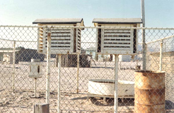
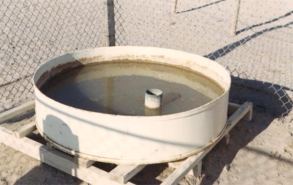
San Felipe is among the numerous villages of Baja California to have a weather recording station. The station is located approximately one-half mile from the shore in a predominately residential area. A small, fence-enclosed area contains two shelters, an evaporation pan, rain gauge, and wind vane. One shelter houses a maximum and minimum thermometer and the other contains a non-functioning hygrograph. Behind the shelters is a crudely constructed wind vane, and evaporation pan filled with stagnant water, and a rain gauge which receives little attention (plates 3 & 4).
|
Plate 3. The Weather Station at San Felipe. |
|
Plate 4. A Little-used Evaporation Pan with Stagnant Water. |
Weekly compilation of data is sent to the office of Secretaria de Recursos Hidraulicos. There the data are added to San Felipe's continuous record beginning with 1948.
The Mexican agency, Secretaria de Recursos Hidraulicos, has compiled data for all stations of Northern Baja California back to 1956. Pre-1956 data for all stations of Lower California can be found in a recent publication by James Rodney Hastings [James Rodney Hastings (ed.), Climatological Data for Baja California (Technical Reports on the Meteorology and Climatology of Arid Regions, No. 14), p. 93.]
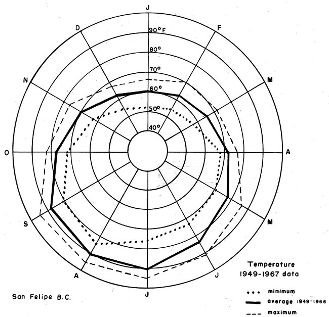
Temperature. Predominantly clear skies resulting from stable conditions associated with the subtropical belt of high pressure have much influence on the temperature at San Felipe. Afternoon peak temperatures lessen pressure over the land causing a gulf breeze to blow inland. This breeze somewhat moderates San Felipe's afternoon temperatures. Daytime summer temperatures of 115° F. are not uncommon while the minimum in winter falls to 34° F. The average annual range of temperatures for the period 1949 to 1966 varies between 63° F. in December and 90° F. in August. The mean annual temperature for this same period is 75.6°F. (Appendix A) (fig. 2).
|
Figure 2. Temperature Data for San Felipe 1949-1967. |
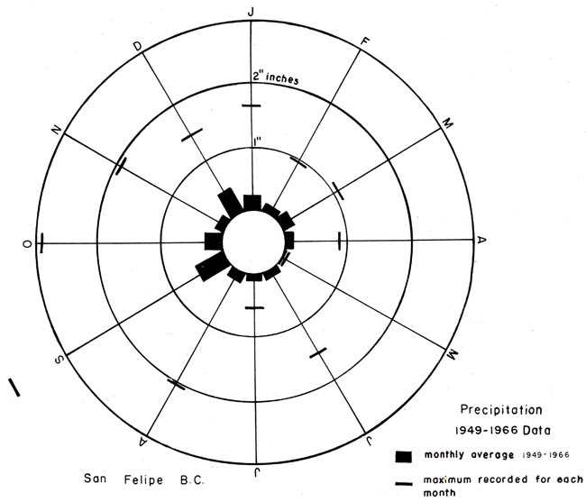
Precipitation. The mean annual rainfall for San Felipe is 2.18" for the period 1949 to 1966 (Appendix B). Two periods of maximum rainfall are discovered in the annual precipitation records of San Felipe. Maximum periods are in the summer and winter seasons. Winter rainfall is attributed to frontal storms that sweep in from the pacific, crossing the peninsula's mountain barrier. Summer convective storms occur particularly during the months of August, September, and October (fig. 3).
|
Figure 3. Precipitation Data for San Felipe 1949-1967. |
The mountains of the peninsula receive four to five times more total annual precipitation than does the Baja California desert. Much of the water from the mountains flows down slope and underground through the desert alluvium to the gulf. The presence of available ground water was discovered early and has been a major factor in the historical settlement of San Felipe's bay site.
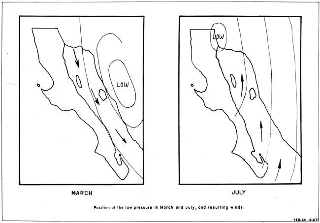
Pressure and Winds. The prevailing winds in the Gulf of California have two primary directions. They are northwesterly between November and May and southwesterly during the remainder of the year. These wind conditions are governed by the shift of low pressure cells during the year. In March a low pressure cell is situated inland from the coast of Western Mexico, drawing breezes from the northern gulf area. In July the low shifts and centers over the mouth of the Colorado River drawing wind from the southwest (fig.4). Moderate northwest gales, usually lasting two to three days, are frequently experienced in the upper gulf during the months of December, January, and February. These winds may be caused by cyclonic disturbances in upper California. [United States Hydrographic Office, Sailing Directions for the West Coasts of Mexico and Central America--The United States to Colombia including the Gulfs of California and Panama, 9th ed. (Washington: Government Printing Office, 1951, p. 15.]
|
Figure 4. Positioning of the Low Pressure System in March and July,and Resultant Winds. |
Knowledge of winds is important to the fishermen of San Felipe. These experienced men of the gulf look to wisps of clouds for wind direction and possible evidence of coming gales. Many lives have been lost by unsuspecting fishermen who have proceeded out to sea in the morning calm only to have been caught in an afternoon surging torrent of wind and waves.
III. CLIMATIC CLASSIFICATION
Application of San Felipe's climatic data to Glenn Trewartha's climatic classification table, places San Felipe within the (BW) tropical or subtropical desert. This desert experiences temperatures above 32°F. (0°C.) all months of the year. The subtype (h) can also be included in the climatic type placing (BWh) as the final climatic classification of San Felipe (fig. 5).
|
Figure 5. Trewartha Climatic Classification of the San Felipe Area. |
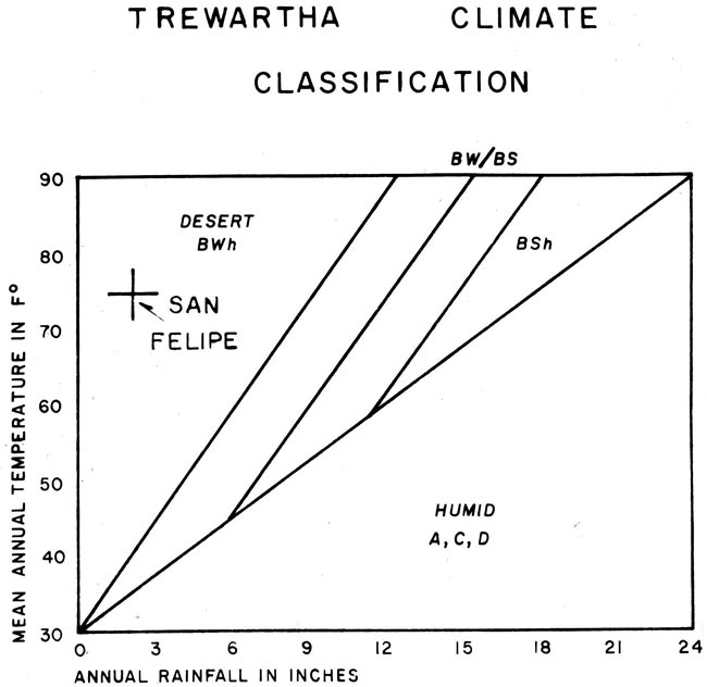
TABLE OF CONTENTS: HISTORY OF SAN FELIPE SITE EVOLUTION, BY THOMAS ANTHONY TERICH
(Related San Felipe articles and reports may be found at Mexfish.com's main San Felipe information page. See weekly fishing news, photos, and reports from the major sportfishing vacation areas of Mexico including the San Felipe area in "Mexico Fishing News.")
MEXICO FISHING INFO SAN FELIPE FISHING INFO "WEEKLY MEXICO FISHING NEWS" FISH PHOTO GALLERY