
Mex 1 Full-Length Post-Hurricane Survey
![]()
|
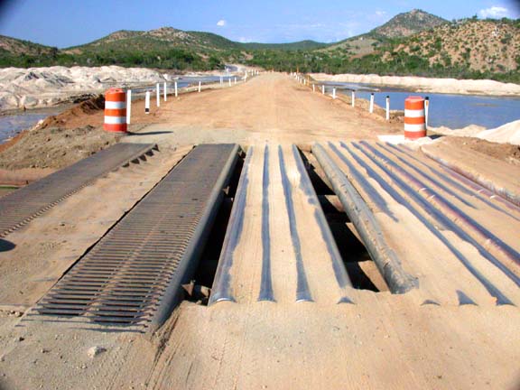
The worst post-Hurricane Juliette hazard remaining on Baja's main highways is this temporary bridge crossing about 27 miles south of Todos Santos, Baja California Sur, Mexico. See text of article. |
CHECKING THE STORM DAMAGE ON BAJA CALIFORNIA'S TRANSPENINSULAR HIGHWAY
By Gene Kira, Oct. 28, 2001, as published in Western Outdoor News:
A full-length survey last week of Baja California's Mex 1, the Transpeninsular Highway, showed road conditions generally excellent from the border south to Mulege, but still feeling the effects of last month's Hurricane Juliette from there to Cabo San Lucas.
Large crews with heavy equipment were working to widen the roadbed in many places, and new pavement was being laid down in many sectors. The entire highway, including both the East Cape and Todos Santos southern branches from La Paz to Cabo, was passable by busses and heavy trucks.
Following here are section-by-section observations taken late last week. Unless otherwise noted, Baja road conditions observed were "normal" for Mex 1, including sections with narrow, no-shoulder roadbeds, sharp edge drop-offs, occasional potholes, small edge erosion, concrete culvert lintels very close to the pavement edge, and other miscellaneous road hazards that may require caution. Mileages given are approximate. Unless otherwise noted, all detours and dirt filled crossings were found to be passable with care by most vehicles.
|
|
- TIJUANA TO EL ROSARIO: Generally excellent condition to about 20 miles south of El Rosario. Wide and smooth with newly painted center and edge lines.
- EL ROSARIO TO CATAVINA: Numerous short stretches of moderately roughened pavement. Numerous small areas of edge erosion going a few inches inside edge line. Overall condition good.
- CATAVINA TO LAGUNA CHAPALA: Not new, but in good condition. Some stretches of slightly roughened pavement. Had to look hard to find six small "potholettes" about 14 miles south of El Rosario.
- LAGUNA CHAPALA TO GUERRERO NEGRO: At 14 miles, some potholes and slightly roughened pavement. Generally in good condition.
- GUERRERO NEGRO TO MULEGE: No unusual problems.
- MULEGE TO LORETO: Many small to moderate areas of edge erosion from here south to Cabo San Lucas. Two small dirt filled sections leaving town. A little lumpy for very low clearance vehicles, but busses and trucks passing through.
Mile 5: 100-yard detour. Rocks on edge of road.
Mile 12: 50-foot dirt fill.
Mile 20: 40-foot dirt fill. Bumpy with small rocks.
Mile 21: 200-foot dirt fill. One-lane arroyo crossing.
More instances of the same at miles, 30, 31, 42, 57, 59, 63, and 75.
- LORETO TO PUERTO ESCONDIDO: Short dirt fills, one-lane sections, and rough spots at miles 1 and 5. Rocks on roadbed at mile 12. Puerto Escondido road to launch ramp is in perfect condition.
- PUERTO ESCONDIDO TO CIUDAD INSURGENTES: Section of dirt fills at mile 62. Otherwise nominal.
- CIUDAD INSURGENTES TO CIUDAD CONSTITUCION: One-lane section at mile 8. Otherwise nominal.
- CIUDAD INSURGENTES TO LA PAZ: Generally, in excellent condition, but with the following exceptions.
Mile 32: One-lane section (Santa Rita). Sharp dirt bumps at bridge require caution.
Mile 44: 12 miles of new blacktop with light sand on surface.
Mile 60: Several dirt fills. Sharp bumps on bridge approaches (Las Pocitas) require caution.
Mile 66: 50-yard dirt fill near El Cien requires slowing.
Mile 69: 1.5 mile dirt side road beside large paving crew.
Mile 72: 2-mile dirt side road beside another large paving crew.
Mile 75: Large and dangerous dip in northbound lane.
Mile 81: Potholes.
Mile 116: Sink hole in southbound lane.
LA PAZ TO PICHILINGUE: Good condition, except for one dirt fill and one total washout with short detour that requires caution, but passable by most vehicles.
LA PAZ TO MAIN ROAD FORK AT SAN PEDRO: Small dirt fills at miles 5, 7, 14, and 15.
(WESTERN LOOP)
SAN PEDRO TO TODOS SANTOS: Dirt fills and side cutouts at miles 23 and 28.
TODOS SANTOS TO CABO SAN LUCAS:
Mile 4: 50-foot dirt fill, requires caution.
Mile 15: 300-yard dirt fill. Fifty-foot-wide stream running under road through temporary culvert. One-lane section requires caution.
Mile 17: Several small dirt fills.
Mile 18: 100-foot dirt fill with 3 inches of water flowing over rough pavement.
Mile 20: Edge erosion requires caution.
Mile 24: 100-foot gravel fill with 1 inch of water on road. Hard bottom. Another dirt fill closely following.
Mile 24.7: 100-yard dirt fill, with water flowing 1 inch deep. A little soft, but not too deep. All vehicles crossing.
Mile 26: 1 inch of water flowing across blacktop.
Mile 27: One-third mile dirt fill. Very dangerous pipe and steel plate temporary bridge at south end. Use extreme caution. Note two wide gaps running parallel to roadbed in center of road. All vehicles crossing, but watch it.
Mile 31: Enormous pothole.
Otherwise, nominal the rest of the way into Cabo.
(EASTERN LOOP)
SAN PEDRO TO EL TRIUNFO: Nominal.
|
|
EL TRIUNFO TO SAN ANTONIO: Rocks on road at mile 3. Otherwise nominal.
SAN ANTONIO TO SAN BARTOLO: Numerous small areas of edge erosion.
Mile 5: 100-foot, 1-lane fill. Rocks on road near eroding cliff and landslide.
Mile 15: Big pothole. Begin 2 miles of many small dirt fills entering San Bartolo.
SAN BARTOLO TO LOS BARRILES: Light sand on road in town. Eight topes (speed bumps) make this the tope capital of Baja. Lots of edge erosion to Los Barriles.
Mile 3: 1-lane bridge crossing. Tight passage around work crew.
Mile 6: 200-yard dirt fill. 30-yard hard bottom water crossing, 2 inches deep.
Mile 9: Big arroyo crossing. Easy 1,000-foot dirt fill. Dry.
LOS BARRILES TO MIRAFLORES: Generally excellent condition, except as noted.
Mile 7: Several small dirt fills.
Mile 10: One-third mile crossing of Las Cuevas Arroyo. Short one-lane section. Easy dirt crossing. Dry roadbed, with water flowing through culverts.
MIRAFLORES TO SANTA ANITA: Generally good, except for dirt fills around mile 3, with a sharp, 6-inch bump that requires caution. Another fill at mile 7.
SANTA ANITA TO SAN JOSE DEL CABO: Several bumpy dirt fills leaving town. All vehicles passing through.
SAN JOSE DEL CABO TO CABO SAN LUCAS: All nominal, except for El Tule Arroyo crossing at mile 10. Westbound bridge lane has 1,000 feet of dirt fill. Eastbound lane on riverbed has 1,000 feet of bumpier dirt fill. All vehicles passing. Some small dirt fills entering Cabo San Lucas.
(Related Baja California, Mexico, articles and reports may be found at Mexfish.com's main Baja California information page. See weekly fishing news, photos, and reports from the major sportfishing vacation areas of Mexico including the Baja California area in "Mexico Fishing News.")
MEXICO FISHING INFO BAJA FISHING INFO "WEEKLY MEXICO FISHING NEWS" FISH PHOTO GALLERY